- Rental
- Subsea and Offshore
- Subsea Inspection
- Topside NDT & Inspection
- Ex-Rental Equipment
- Personnel
- Products
- Consumables
- Service and Calibration
- Oceanscan
- Support
RENISHAW MERLIN LASER SCANNER
RENISHAW MERLIN LASER SCANNER
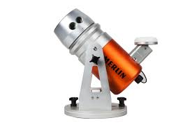
Merlin’s scanning laser sensor has a 250 m range capability for the accurate, long-range mapping of coastal and inland waterways. The scanner also has a 360° field of view, which aids the collection of detailed above-water 3D point clouds.The information acquired by Merlin combines seamlessly with below-water acoustic bathymetric data for complete datasets that reveal the full landscape above and below the waterline.Merlin can either be internally time tagged at source, using its own onboard L1 GPS receiver or time tagging can be provided by the appropriate National Marine ElectronicsAssociation (NMEA) data stream from the vessel’s existing onboard positional equipment. This ensures ease of software processing and vastly improves the quality of the 3D models that are created when the two data types are combined
Download files
Request for Information
Take advantage of over 50 years combined experience from our sales team.
29/01/2024
Oceanscan participated at the annual BINDT Workshop and Burns Supper event in Johnstone (Glasgow) on Friday 26 January 2024.
- Read More...
15/01/2024
Oceancan sponsors Exail's annual 2024 User Conference which takes place on the 23rd January 2024 in Saint-Germain in Paris.
- Read More...
24/01/2024
Geoforce Technical Services, an Oceanscan company, has acquired a new powerful VKG Vibrocorer system enabling an operator to obtain sediment cores.
- Read More...
17/01/2024
Eddyfi Technologies Floor Scanner 3Di for rent from our Aberdeen facility.
- Read More...