RANGER 2 ACOUSTIC POSITIONING SYSTEM
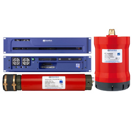
Ranger 2 is a survey grade Ultra-Short BaseLine (USBL) acoustic positioning system designed for deep water, long range tracking of underwater targets and position referencing for dynamically positioned (DP) vessels. The system calculates the position of a subsea target, for example, an ROV, by measuring the range and bearing from a vessel-mounted transceiver to an acoustic transponder fitted to the target. Multiple subsea targets over a wide area and range of water depths can be simultaneously and precisely positioned.
Ranger 2 builds on the simplicity and reliability of Sonardyne’s original Ranger system but adds support for the latest 6G® (Sixth Generation) acoustic instruments and Wideband 2 signal architecture. 6G® systems offer precise acoustic ranging, fast data telemetry and hardware that is easier to set up and operate even in the most challenging subsea operating environments. These features improve the efficiency of survey operations, reduce vessel delays and generate cost savings for owners.
Ranger 2 is available in two versions. In standard configuration, Ranger 2 allows up to 10 subsea targets to be simultaneously tracked from a surface vessel. Operating ranges of greater than 6,000 metres are achievable and the system supports a wide range of industry standard survey and DP output telegrams. One second position updates are achievable in any water depth.
Ranger 2 Pro is designed for complex operations where any number of subsea targets can be tracked. Multiple transceivers and attitude compensation sensors can be simultaneously interfaced into Ranger 2 Pro allowing for highly redundant, bespoke installations. Ranger 2 Pro also supports subsea INS integration, external triggers for acoustic synchronisation and user configurable displays.
NOW INCLUDES THE RANGER 2 SURVEY PACK
The Ranger 2 Survey pack uses the intuitive and simple layout as the standard software but allows access to more complex areas such as the setup and tracking of ROVs, AUV's and structures. These objects can be configured with multiple transponders attached to them and fixed offsets can then be computed to points such as a structure’s CRP or an ROV’s bumper bar which can be both displayed on-screen with their position output.
Being able to work in this manner directly in the USBL software benefits your surveys as any sensor latency induced errors are minimised, and the risk of systematic errors from the use of incorrect offsets is reduced. AutoCAD backdrops and configurable seabed
geodesy allow Ranger 2 Survey to be used for tracking and guidance. Complex doesn’t have to be complicated
Download files